The 1,707-meter high Trainsjoch is situated on the border between Bavaria and Tyrol and is considered one of the most beautiful panoramic peaks in the Bayrischzell region, despite its relatively low height.
The hike presented here follows the Fritz-Koeber Trail, which provides a bit of a high-alpine feeling.
Here you'll find all the information about the hike to Trainsjoch, including a map and GPS track for download.
Summary of Trainsjoch
Moderate mountain hike
Duration: 4 to 5 hours
Distance: 12.3 kilometers
Ascent: 910 meters
Descent: 910 meters
Hiking parking lot Mariandlalm (4 euros per day; Google Maps)
Starting the hike to Trainsjoch


From the hiking parking lot Mariandlalm in Tyrol, initially follow the wide road on the opposite side upwards. Here, you hike along the rushing Trockenbach, which offers some beautiful waterfalls.
After 15 minutes, you can decide to ascend left via the marked mountain path or continue on the road. No matter the choice, it's worth taking a look to the right into the gorge. The Trockenbach springs from a rock crevice in the mountain here - a beautiful photo opportunity.
Those who follow the road should take the next fork to the left and continue along the path with views past the Untere Trockenbachalm and shortly thereafter the Obere Trockenbachalm.
The Mariandlalm

The much-loved Mariandlalm (Website) can be reached via both routes after about an hour (3.1 kilometers). The rustic alpine hut is situated in a breathtaking mountain backdrop and is particularly popular on weekends as a tourist destination. In addition to delicious cakes, you can find dishes like Kaiserschmarrn or Kaspressknödel. Overnight stays are also available in the hut.
The Mariandlalm is generally open year-round. In the summer months, Monday is a rest day. In the cold season, Monday, Tuesday, and Thursday are rest days!
Ascent via the Fritz-Koeber Trail
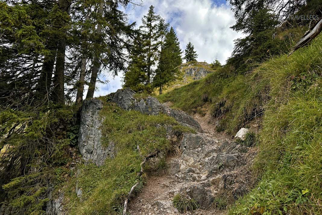


After the Mariandlalm, keep to the left. This route leads to Trainsjoch via the Fritz-Koeber Trail. The ascent along the trail is extremely scenic and quite enjoyable! In some sections, there are high rock steps, and at times, you also have to climb a bit and utilize your hands for assistance. Sure-footedness is essential here.
Especially the last meters up to the Trainsjoch peak, which you can see from a distance, are quite steep and require good stamina.
The Trainsjoch Peak


At the 1,707-meter-high Trainsjoch peak (5 kilometers, about 2 to 3 hours of ascent) on the German-Austrian border, you're greeted with an incredible 360-degree panoramic view. Not far away, the impressive Kaisergebirge rises with the Ellmauer Halt towering above. In the distance, you can even see the Olympic Mountain in Munich.
At this point, it's a good time to unpack your snacks and enjoy the magnificent Alpine panorama.
The Return Way

From the Trainsjoch peak, choose the southern descent toward Trainsalm. The path is significantly easier than the ascent variant presented here via the Fritz-Koeber Trail and is consequently fairly well-trodden.
At the next fork, you can either descend to the already familiar Mariandlalm (and stop here on the return) or proceed straight ahead and 'climb' the Ascherjoch and the Saurüssel, two elevations that can only be spotted on the map. This variant is rarely traveled, and the path along a wooded ridge is occasionally difficult to discern despite the existing red-and-white markings and can sometimes be overgrown.
One descends to the unmaintained Ascherjochalm and then follows the wide road down into the valley. Eventually, you will encounter the well-known ascent path again.
What you need to know about the hike to Trainsjoch
With over 900 meters of elevation gain and some light climbing sections, the hike to Trainsjoch can definitely be classified as a moderate mountain hike. There are no truly difficult or exposed sections on the route. Those who are accustomed to hiking in the mountains with significant elevation changes and light climbing will have a lot of fun.
The panoramic view from the peak is truly fantastic, despite its relatively low height. Personally, I enjoyed the tour very much!
If you don't feel comfortable with the easy climbing sections, you can skip the Fritz-Koeber Trail and choose the descent variant from Trainsjoch presented here for both the ascent and descent. The way to and from the Mariandlalm is completely straightforward and manageable even for beginners.
Interactive map for the hike + GPS Track
Here you can find the map for the hike to Trainsjoch. You can also download the GPS track for the hike to Trainsjoch here.
Guidebook for the Bavarian Pre-Alps
*Affiliate Link / Images from the Amazon Product Advertising API